

Description
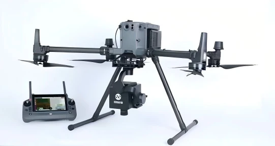
The new generation of drone-mounted hyperspectral imaging systems can enable detectors with high acquisition frame rates to output high signal-to-noise ratio, high spatial and spectral resolution, and high-precision hyperspectral data under the front optical path of high light flux and high transmission efficiency. It can also meet the needs of using built-in push-broom imaging when hovering.
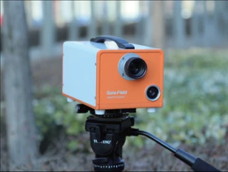
Gaiasky-mini-VN Hyperspectral Imaging Camera
Specifications
| Number Of Channels: | >4 |
|---|---|
| Sensor Type: | CCD |
| Wavelength Range: | 400 – 1000 nm |
| Spectral Resolution: | 5 nm |
| Number Of Spatial Channels: | 1024 |
| Number Of Spectral Channels: | 448 (1x),224(2x) |
| Spectral Sampling Interval: | 2.7nm@224, 1.4nm@448 |
| Lmage Resolution: | 1024x1003 |
| Imaging Lens: | 16mm, 25mm |
| Lmage Bit Depth: | 12 bit |
| Output Interface: | USB3.0 |
| Operating Voltage: | 12V |
| Power: | 45W |
| Mounting Platform: | DJI M350/M300 |
| Auxiliary Camera: | 500W Pixel Real -time lmaging |
| Horizontal Field Of View: | 35°@16mm, 23°@25mm |
| Weight: | 1.2kg |
Got questions about specs? Use the inquiry form to ask.
Features
- Unique imaging structure: The system adopts a scanning imaging structure with completely independent domestic and international invention patents, which effectively improves the efficiency and quality of data collection.
- Control method: Use the remote control to apply various functions, which is convenient, fast and flexible.
- Appearance design: Unique appearance design and control provide a good platform and stability for the quality and multi-dimensional application of the system. The unique monitoring module provides real-time on-site environmental conditions,forming "what you see is what you get".
- Software function: Rapid real-time calibration outputs inversion, classification and recognition results for users online,allowing rapid decision-making for industry applications.
- Data stitching: The correction software is hardware and software for large-area data stitching, which fully improves the data quality and work efficiency of the system.
- Load: Other products can be selected according to actual application requirements.
Applications
Rapid identification and classification of land objects
Rapid identification and classification of ground objects is very important in remote sensing, and different ground object categories are widely used in surveying and mapping, urban planning, forestry, etc. Compared with multispectral systems, UAV hyperspectral systems have more spectral bands and higher spectral resolution, so they can obtain different responses of different ground objects in different wavelength bands, thereby achieving fast and high-precision image classification and recognition.
Crop biochemical parameter detection
During the process of obtaining images by the drone hyperspectral system, farmers can choose different vegetation indices to reflect crop growth and diseases. Vegetation indices include the Green Normalized Vegetation Index Improved Chlorophyll Absorption Index (TCARI), the Visible Atmospheric Impedance Index (VARI) Ratio Vegetation Index (RVI), and the Soil Adjusted Vegetation Index (OSAVI). Farmers can also choose to directly reflect crop indicators, such as leaf nitrogen, phosphorus, and potassium content, chlorophyll content, leaf area index, P content, and K content. Users can also customize vegetation indices for real-time demonstration as needed.
Soil moisture content and soil fertility analysis
The UAV hyperspectral system can obtain soil moisture content, soil total fertility content and organic matter content distribution map during its hyperspectral image acquisition process. According to the soil moisture content and soil fertility distribution map, farmers can irrigate and fertilize quantitatively, thus saving costs and avoiding environmental pollution.
water body monitoring
Hyperspectral remote sensing is widely used in remote sensing water quality monitoring due to its high precision, multi-band.and large amount of information, which greatly improves the estimation accuracy of water quality parameters. With the continuous advancement of remote sensing technology,water quality monitoring has shifted from qualitative description to quantitative analysis. At the same time, the number of water quality parameters that can be monitored has gradually increased, and the inversion accuracy has also been continuously improved, playing a significant role in the protection, planning and sustainable development of water resources. Water quality parameters such as chlorophyll a, total nitrogen, total phosphorus, suspended solids and turbidity can be inverted for rivers.
Forest vegetation health monitoring (hot spots & dark spots)
Multi-angle remote sensing observations are an important meanst o study the BRDF (Bidirectional Reflectance Distribution Function)characteristics of vegetation canopies. However, there are currently few multi-angle remote sensing observations and data with continuous interval sampling of forest canopies, and observations in hotspot directions are particularly lacking.
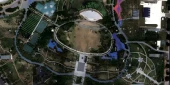
Using the unique patented technology, the drone can fly to a certain height, hover in the air, use the gimbal to rotate to the same angleas the direction of sunlight, and then use the built-in push-scanmethod of the hyperspectral imager to quickly obtain the imaging spectral information of the ground objects at that angle (under normal lighting conditions, a scene of hyperspectral image information can beobtained within 10 seconds. At an altitude of 100m,the corresponding ground area is about 43m*43m). The figure below shows a photo of the hot spot effect of the ground object taken by the drone hyperspectral imaging system at a rotating angle in the air.
Frequently Asked Questions
What is the resolution of the GaiaSky-mini-VN Hyperspectral Imaging Camera?
What is the spectral region that the camera can capture?
Can the camera automatically adjust exposure time?
Is it possible to change the lens on the GaiaSky-mini-VN camera?
What are some of the applications for the GaiaSky-mini-VN camera?
Got more questions? Use the RFQ form to ask the supplier directly.
Similar Products
Need pricing for this product? Send a quick inquiry
Your inquiry has been received.
Create an account by adding a password
Why create an account?
- Auto-complete inquiry forms
- View and manage all your past messages
- Save products to your favorites
- Close your account anytime — no hassle