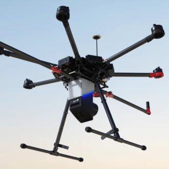
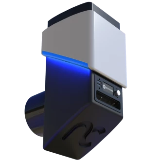
NextCore RN50 Drone LiDAR Unit
Description
Introducing the NextCore RN50 Drone LiDAR Unit, designed by Airsight. A user-friendly system built specifically for the DJI M600 flying platform, RN50 is accurate to 50mm and boasts lightning-fast, cloud-based processing. The unit comes as payload-only option, allowing operators who already have access to suitable GNSS data to use their existing base station equipment or RINEX subscriptions.
NextCore RN50 Drone LiDAR Unit
Specifications |
|
|---|---|
| Laser Wavelength: | 905 nm |
| Scanning Angle: | 360 deg |
| Scanning Frequency Range: | 1-420000Hz |
| Angular Resolution: | 20 deg |
| Measurement Range: | 1.0-150m |
| Distance Resolution: | 50 mm |
For pricing, technical or any other questions please contact the supplier
- No registration required
- No markups, no fees
- Direct contact with supplier
-
Ships from:
United Kingdom
-
Sold by:
-
On FindLight:
External Vendor

Claim Level Five Supplies Page to edit and add data
Frequently Asked Questions
The flight time of the NextCore RN50 Drone LiDAR Unit on M600 is 23 minutes (on M600 with TB48s).
The laser range of the NextCore RN50 Drone LiDAR Unit is >150 m @ 80% Reflectivity.
The NextCore RN50 Drone LiDAR Unit is a user-friendly system built specifically for the DJI M600 flying platform, accurate to 50mm and boasts lightning-fast, cloud-based processing.
The recommended scanning height for the NextCore RN50 Drone LiDAR Unit is AGL 20 - 60 m.
The recommended UAV for the NextCore RN50 Drone LiDAR Unit is DJI M600 Pro.